
Municipality · 1st District
Caraga
A municipality of the Province of Davao Oriental with 17 barangays. This page brings together public records about the community and the provincial projects located there.
Photo: Provincial Information Office, Provincial Government of Davao Oriental · Philippine government work (RA 8293 Sec. 176)
Key figures
At a glance
- Population2024 Census of Population
- 39,630
- Population2020 Census of Population and Housing
- 39,704
- Land area
- 642.7km²
- Barangays2 urban, 15 rural (2020 census basis)
- 17
- Change in population, 2020 to 2024-0.2% · derived from the two censuses
- -74
- Population densityDerived: 2024 population ÷ land area
- 61.7per km²
- Income classificationDepartment of Finance, as carried in the PSGC
- 1st class
- Legislative district
- 1stDistrict
Public record · pending validationSource: PSA, Philippine Standard Geographic Code (PSGC) 2Q 2026 Publication Datafile (publication date 30 June 2026)Reference period: PSGC 2Q 2026; 2020 and 2024 censusesLast updated:
PSGC code 1102504000 · Source of each field
Profile
About Caraga
Community profile not yet supplied
- Responsible office
- Provincial Planning and Development Office, with the municipal government of Caraga
- Required source
- Profile text approved by the municipal government (for example from its Comprehensive Land Use Plan or socio-economic profile)
Major industries
Not yet supplied
- Required source
- Economic profile from the municipal government
Infrastructure
Not yet supplied
- Required source
- Infrastructure inventory from the Provincial Engineer's Office and the local government
Caraga has its own local government
The municipal government of Caraga is a separate local government with its own elected officials, budget and offices under the Local Government Code (Republic Act No. 7160). The Provincial Government does not run its operations. Its city or municipal hall — not the Capitol — handles business permits, civil registry (birth, marriage and death certificates), real property tax payments, building permits, local health centers and barangay matters.
For hospitals, provincial roads, scholarships and other services of the Provincial Government, see provincial services.
Geographic location
Where Caraga is
The orange outline is the boundary of Caraga; shaded areas are its 17 barangays, which are also listed in the table below. Administrative boundaries: NAMRIA and PSA via OCHA COD-AB (CC BY-IGO), processed by faeldon/philippines-json-maps (MIT). PSGC 3Q 2026 vintage, retrieved 16 November 2026. Indicative boundaries — not authoritative cadastral or legal boundaries.
Barangay directory
The 17 barangays of Caraga
17 of 17 barangaysCombined 2024 population: 39,630
| Barangay | Classification | Population (2024) | Population (2020) | PSGC code |
|---|---|---|---|---|
| AlvarRural | Rural | 695 | 688 | 1102504001 |
| CaningagRural | Rural | 1,186 | 1,148 | 1102504002 |
| Don Leon BalanteRural | Rural | 1,123 | 1,034 | 1102504004 |
| LamiawanRural | Rural | 1,521 | 1,482 | 1102504005 |
| ManorigaoRural | Rural | 1,740 | 1,661 | 1102504006 |
| MercedesRural | Rural | 1,292 | 1,190 | 1102504007 |
| Palma GilRural | Rural | 1,800 | 1,887 | 1102504008 |
| PichonRural | Rural | 4,552 | 4,946 | 1102504009 |
| PoblacionUrban | Urban | 5,123 | 5,484 | 1102504010 |
| San AntonioRural | Rural | 2,265 | 2,333 | 1102504011 |
| San JoseRural | Rural | 1,635 | 1,598 | 1102504012 |
| San LuisRural | Rural | 2,521 | 2,491 | 1102504013 |
| San MiguelRural | Rural | 1,270 | 1,138 | 1102504014 |
| San PedroRural | Rural | 2,960 | 2,880 | 1102504015 |
| Santa FeRural | Rural | 2,118 | 2,028 | 1102504016 |
| SantiagoRural | Rural | 2,727 | 2,659 | 1102504017 |
| SobrecareyUrban | Urban | 5,102 | 5,057 | 1102504018 |
Public record · pending validationSource: PSA — Philippine Standard Geographic Code; 2020 Census of Population and HousingReference period: 2020 Census of Population and Housing (1 May 2020)
Tourist attractions
Places to visit in Caraga
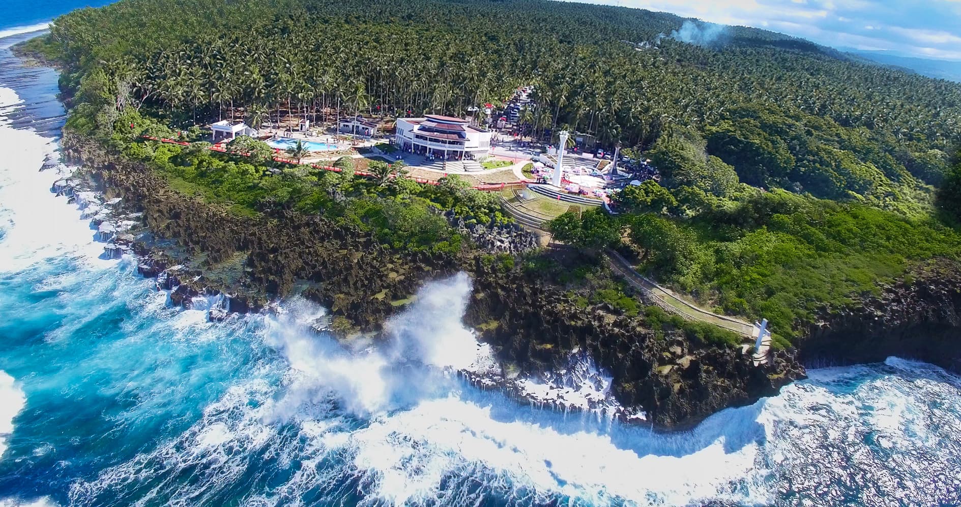
Pusan Point
A promontory in Barangay Santiago, Caraga, described as the easternmost point of the Philippines. It drew national attention during the millennium celebrations as the first place in the country to see the sunrise.
Public record · pending validationPhoto: Provincial Information Office, Provincial Government of Davao Oriental · Philippine government work (RA 8293 Sec. 176)
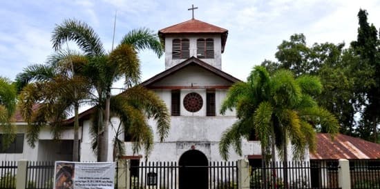
San Salvador del Mundo Church (Caraga Church)
The Roman Catholic parish church of Caraga, a stone-and-wood mission church completed in 1884 and described by the provincial government as Mindanao's oldest church. It was restored by the National Historical Commission of the Philippines and reopened in July 2020.
Public record · pending validationPhoto: Olan214 · CC BY-SA 3.0
Provincial projects and programs
Provincial Government projects in Caraga
Projects funded or implemented by the Provincial Government and located here. Projects of the municipal government itself are published by that government, not on this website.
Programs implemented here:[Demo] Rural water supply program[Demo] Health facilities enhancement program[Demo] Bridge programAbout provincial programs
| Project | Priority area | Implementing office | Status | Physical progress |
|---|---|---|---|---|
| [Demo] Level II water system — Caraga (sample 13)[Demo] Rural water supply programBarangay Palma Gil, Caraga, Davao OrientalDemonstration data | Water | Provincial Engineer's Office | Completed | 100%as of Feb 25, 2024 |
| [Demo] Medical equipment provision — Caraga (sample 27)[Demo] Health facilities enhancement programBarangay Poblacion, Caraga, Davao OrientalDemonstration data | Health | Provincial Health Office | Planned | Not yet validated |
| [Demo] Public transport terminal improvement — Caraga (sample 12)[Demo] Bridge programBarangay San Jose, Caraga, Davao OrientalDemonstration data | Transportation | Provincial Engineer's Office | Ongoing | 77.8%as of Oct 31, 2026 |
Local government
Contacting the municipal government
Contact details not yet confirmed
- Responsible office
- Municipal Government of Caraga, through the Provincial Information Office
- Required source
- Official website address, trunkline, e-mail and office address confirmed by the local government
Sources for this page, field by field
psgc, name, type, incomeClass, barangayCount, population[2024]
PSA, Philippine Standard Geographic Code (PSGC) 2Q 2026 Publication Datafile (publication date 30 June 2026) · retrieved Nov 16, 2026
population[2020]
PSA, Philippine Standard Geographic Code (PSGC) 1Q 2025 Publication Datafile (publication date 31 March 2025) · retrieved Nov 16, 2026
psgc, name, isCapital (cross-check)
PSGC API (psgc.gitlab.io), Davao Oriental cities-municipalities and barangays · retrieved Nov 16, 2026
landAreaKm2, centerPoint; population[2020] and barangayCount cross-check
PhilAtlas (secondary; states population and land-area figures are derived from PSA) · retrieved Nov 16, 2026
legislativeDistrict
Provincial Government of Davao Oriental, "Facts About Davao Oriental" (source credited on page: DTI Provincial Office), archived 2022-06-20 · retrieved Nov 16, 2026
centroid (computed from boundary polygon)
faeldon/philippines-json-maps v1.1.1 (PSGC 3Q 2026), from OCHA COD-AB (NAMRIA / PSA) · retrieved Nov 16, 2026
Public record · pending validation
Working together
Provincial activities in Caraga
No activities have been published yet